
Professional ALTA Surveys in Ogden, Utah
Accurate, Reliable, and Trusted by Developers
Partner with Northern Utah's Experienced Land Surveyors to Protect Your Investment and Ensure Your Project’s Success
When you’re investing in property, unexpected surprises can cost you thousands—but a professional ALTA survey keeps costly pitfalls out of your way. At Highland Surveying, we specialize in comprehensive ALTA surveys in Ogden, Weber County, Layton, and throughout Northern Utah, providing the detailed insight you need to confidently move forward.
Our experienced team meticulously evaluates your property, uncovering hidden risks such as boundary disputes, unknown easements, or unforeseen utility conflicts. With our careful attention to detail and thorough due diligence, you'll avoid delays, reduce unexpected costs, and set your project up for seamless success. Trust our experts to protect your investment every step of the way.
Experienced Legal ALTA Surveys
An ALTA Survey (American Land Title Association Survey) is a detailed land survey that provides comprehensive insights into a property’s boundaries, improvements, easements, rights-of-way, utilities, and potential encroachments. It meets strict standards set by both the American Land Title Association (ALTA) and the National Society of Professional Surveyors (NSPS), essential for commercial developers, lenders, and real estate transactions.
ALTA surveys are typically required for:
Commercial Real Estate Purchases
Protect your investment by uncovering hidden property issues before finalizing the deal.
Financing or Refinancing
Many lenders require an ALTA Survey to verify property value and ensure clear title.
Development
Projects
Clearly assess development potential and avoid costly construction setbacks.
Legal Transactions and Title Transfers
Resolve legal concerns regarding boundaries, encroachments, and easements.
Our Proven ALTA Survey Process Ensures Accuracy and Peace of Mind
When you partner with Highland Surveying, you benefit from a structured, transparent process designed for accuracy and efficiency:
Step 1: Initial Consultation & Project Assessment
We clearly identify your goals, review preliminary title information, and define your project requirements upfront.
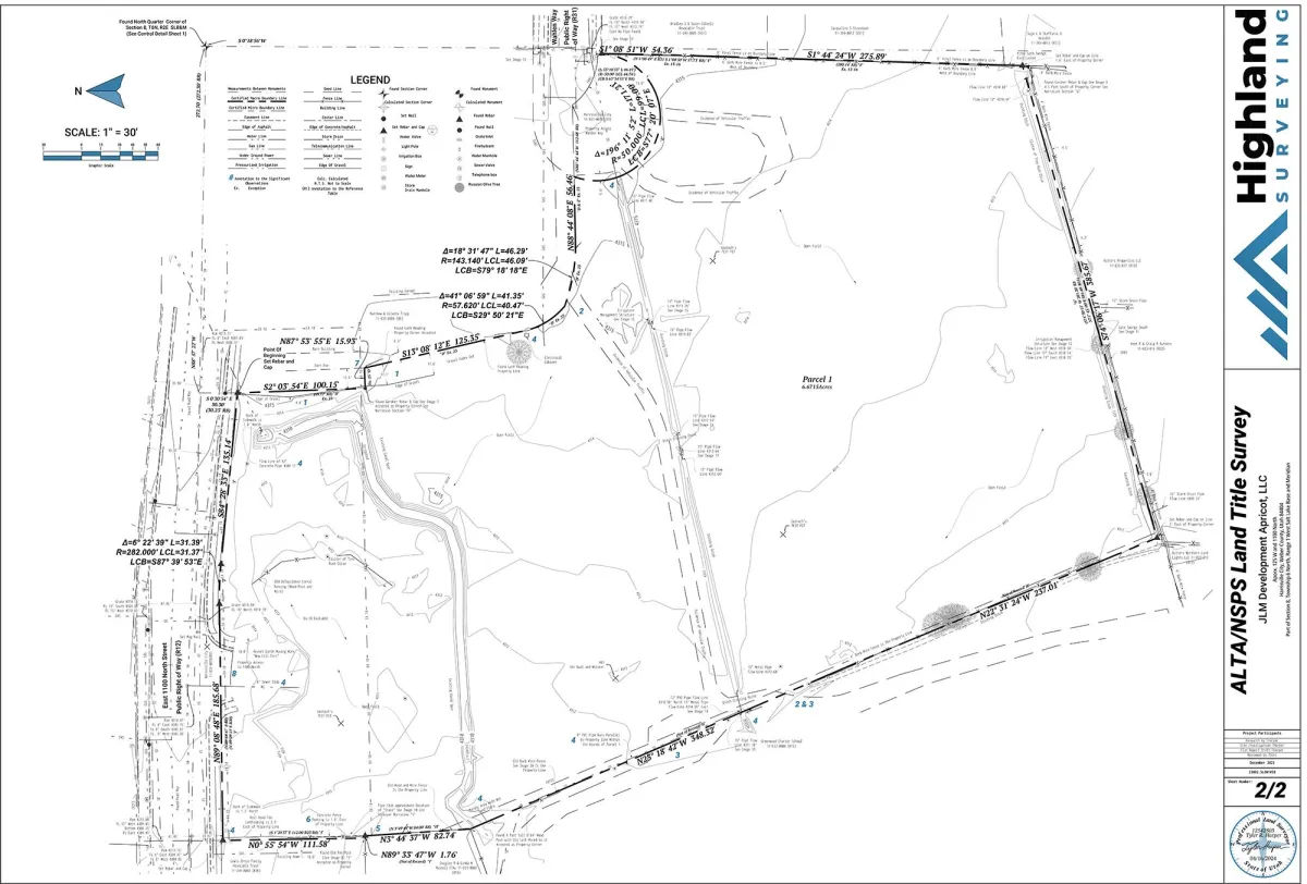
Step 4: Detailed Survey Drafting & Analysis
Our drafting specialists convert precise measurements into clear, accurate ALTA survey maps using advanced CAD software.
Step 2: Comprehensive Research & Due Diligence
Our expert surveyors meticulously research historical records, zoning regulations, title reports, and municipal documentation to avoid unexpected challenges.
Step 5: Thorough Review & Quality Assurance
Senior engineers rigorously review every survey for accuracy, compliance, and quality, ensuring reliable results the first time.
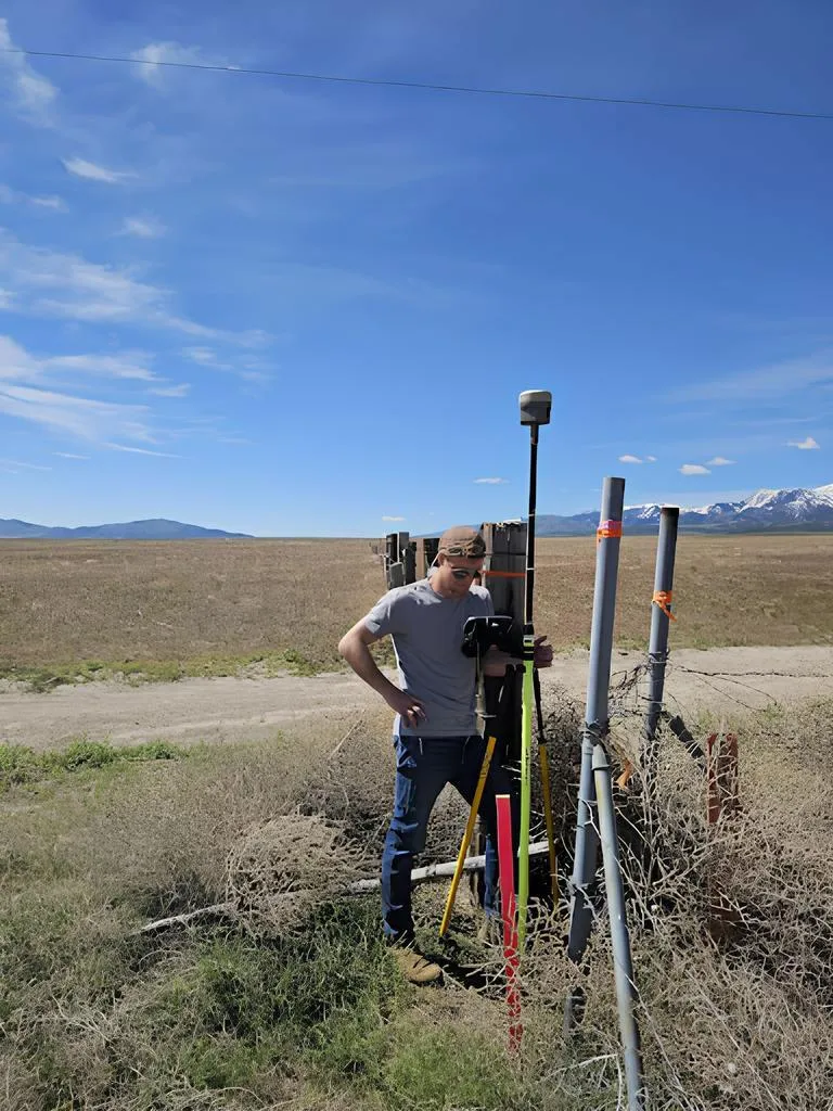
Step 3: Precise Fieldwork & Data Collection
Our experienced surveyors visit your property and accurately establish property boundaries Identify encroachments and boundary discrepancies Locate easements, utilities, buildings, and improvements Document site features precisely
Step 6: Final ALTA Survey Delivery & Ongoing Client Support
We deliver a clear, professional survey ready for immediate use by lenders, title companies, or municipalities, and remain available to provide ongoing guidance.
Common Issues an ALTA Survey Can Uncover and Resolve
An accurate ALTA Survey helps you proactively identify:
Boundary Disputes & Encroachments:
Avoid costly disputes with precise boundary definitions.
Hidden Easements and Rights-of-Way:
Identify restrictions early to prevent development setbacks.
Zoning and Land Use Limitations:
Clarify zoning restrictions upfront to ensure smooth project approvals.
Utility and Infrastructure Conflicts:
Avoid costly delays and unexpected costs by identifying utility locations clearly.
Title and Ownership Concerns:
Resolve potential legal issues before they escalate, protecting your ownership rights.
Why Businesses and Developers in Ogden Trust Highland Surveying
Northern Utah businesses choose Highland Surveying because of our:
Local Expertise: Extensive knowledge of local municipalities, zoning laws, and property regulations.
Personalized Service: Customized surveys tailored specifically to your project.
Proactive Communication: Regular, clear updates, keeping you informed every step of the way.
Value-Engineered Solutions: Strategically designed surveys to maximize profitability and minimize unnecessary costs.
Integrity and Transparency: Commitment to addressing issues promptly and transparently, backed by professional liability insurance.
Don’t settle for generic solutions choose Highland Surveying for a seamless, efficient, and high-quality surveying experience.
Real Stories of Survey Success
Don't just take our word for it – hear directly from property owners who have experienced the transformative power of our ALTA Surveys. Our testimonials showcase real stories of clients who have gained clarity, confidence, and protection for their projects through our meticulous services. These authentic accounts demonstrate the tangible benefits and positive outcomes that our surveys deliver, from saving time and money to avoiding costly disputes.


5 Stars On Google
I had an excellent experience with Highland Surveying. They were quick, professional, and offered a fair price for their top-notch service. The quality of their work was outstanding, and they maintained clear and consistent communication throughout the entire process. Their team was friendly and approachable, making the whole experience smooth and stress-free.
MICHAEL DAN PETERSON

5 Stars On Google
I was completely lost when trying to solve a long standing easement issue. Tyler gave me options, helped me plan, and took steps beyond the standard service to ensure a successful outcome. He is knowledgeable, honest, responsive, and thorough. He made a stressful situation seamless. It was a pleasure to work with him.
Tammy Wright

5 Stars On Google
I came in contact with Tyler from Highland Surveying. Tyler is as very honest and let me know that I probably didn’t need to employee his services. He walked me through other options regarding my land that saved me time and a lot of money. I’m very happy there are honest and helpful people like Tyler.
Spencer Robinson
4.8/5 Stars On Google
Frequently Asked Questions About ALTA Surveys
Our ALTA Land Survey FAQs are designed to provide you with quick and easy access to the information you need to make informed decisions about your project.
We understand that navigating the world of property boundaries can be complex, which is why we've compiled a list of the most common questions asked by our customers and prospects. From understanding the purpose of an ALTA Land Survey to the legal implications of the results, our FAQs aim to offer clarity and transparency about our services.
1. What is an ALTA Survey, and why do I need one?
An ALTA Survey details boundaries, utilities, easements, and improvements, essential for risk reduction in property transactions and development.
2. How much does an ALTA Survey typically cost?
Typically between $2,000 and $5,000, depending on property complexity and size. Contact us for a tailored quote.
3. How long does an ALTA Survey take to complete?
Typically 2-4 weeks, based on property complexity and available data. Rush services are available upon request.
4. What’s included in the final ALTA Survey deliverable?
Detailed maps outlining property boundaries, improvements, utilities, encroachments, easements, and additional required documentation.
5. Does my ALTA Survey expire or need updating?
ALTA Surveys don’t officially expire but are usually updated if older than 6-12 months or if significant property changes occur.
6. How should I prepare for an ALTA Survey?
Provide title documents and property access; we handle the research, measurements, and documentation.
7. Can an ALTA Survey help prevent legal disputes?
Yes, it helps clarify boundaries and easements upfront, significantly reducing legal disputes.
8. How can I get started with Highland Surveying?
Contact us via our online form or call directly. We'll quickly set up your initial consultation.
Ready to Move Forward with Confidence?
Investing in property is significant—and Highland Surveying understands what's at stake. Our meticulous ALTA Surveys offer clarity, accuracy, and peace of mind, allowing informed decisions on your projects. Businesses across Ogden and Northern Utah trust our expertise and personalized service to protect their investments. Don’t leave your project’s success to chance—reach out today!
